
History
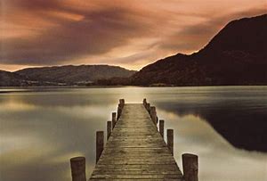
Ullswater is the second largest lake in the English Lake District, being about nine miles (14.5 km) long and 0.75 miles (1.2 km) wide, with a maximum depth a little more than 60 metres (197 ft). Ullswater’s visitor centre website describes it as the most beautiful of England’s lakes; it has been compared to Lake Lucerne in Switzerland as a tourist destination. It is a typical Lake District narrow “ribbon lake” formed after the last ice age by a glacier scooping out the valley floor, which filled with meltwater. Ullswater was formed by three separate glaciers. The surrounding mountains give it the shape of an extenuated ‘Z’ with three segments or reaches winding through surrounding hills. For much of its length, Ullswater formed the border between the historic counties of Cumberland and Westmorland.
Etymology
The origin of the name ‘Ullswater’ is uncertain. Whaley suggests ‘Ulf’s lake’, from Old Norse personal name ‘Ulfr’ plus Middle English ‘water’ influenced in usage by Old Norse ‘vatn’ ‘water’, ‘lake’ ….’Ulfr’ is also the Old Norse noun meaning ‘wolf’, and Hutchinson thought that the name might refer to the lake as a resort of wolves, or…to its elbow-shaped bend (citing a Celtic ‘ulle’…).” Some say it comes from the name of a Nordic chief ‘Ulf’ who ruled over the area;[4] there was also a Saxon Lord of Greystoke called ‘Ulphus’ whose land bordered the lake. The lake may have been named Ulf’s Water in honour of either of these, or it may be named after the Norse god Ullr. Hodgson Hill, an earthwork on the northeast shoreline of Ullswater may be the remains of a Viking fortified settlement.
Settlements
Pooley Bridge is a village in the Eden District of the northwestern English county of Cumbria, within the traditional borders of Westmorland. The village takes its name from a bridge over the River Eamont at the northern end of Ullswater. The bridge, erected in 1764 and replacing an earlier bridge from the 16th century, collapsed on 6 December 2015 when Cumbria was hit by heavy flooding as a result of Storm Desmond. A temporary replacement bridge was opened on 20 March 2016. There is a pier from which ferries (known as the Ullswater ‘Steamers’) provide connections to Glenridding and Howtown. Pooley Bridge was formerly known as Pooley or Pool How meaning the hill by the pool or stream. The name Pool How was derived from the Old English word pollr plus the Old Norse haugr meaning hill or mound. The first actual mention of Pooley is in 1252. The name is, of course, derived from the pool just above where the river emerges from the lake and where there was a V-shaped set of stepping stones. At the apex of the V was a gap where nets were cast to catch fish and it is to this industry that Pooley owes its existence. Fish was sold in the market square where, since medieval times, there had been a cross. Because of its inconvenience to traffic this was removed in the early 19th Century, the probable base still remaining in a local garden.
Originally the landowners were the Earls of Sussex, the Dacre family, but eventually the estate passed via the Musgraves to the Hasells of Dalemain. As the result of the success of the fishing industry the village began to grow. There was a school, founded in 1649, replaced by a new building after the 1870 Education Act, which lasted until 1947. A smithy was built and there were shooting butts.
There were three inns, the Sun and the Crown, which still exist, and the Sloop, which has disappeared. The Pooley Inn, formerly the Chalet, was much later. By 1735 Finkle Street contained rows of houses and in the 1789 Westmorland census the village had 237 inhabitants. The bridge supplanted the stepping stones in the 18th Century. With the coming of tourism in the Lakes towards the end of the 18th Century the inns were modernised and the place grew. Eusmere House was built by the colleague of William Wilberforce in the anti-slavery movement, Thomas Clarkson, friend of Wordsworth.
Boats were now for hire for fishing, and in 1859 the first paddle steamer began to ply on the lake, to be followed by the two boats still in existence. The tourist trade expanded, especially with the coming of the railways to Penrith. Indeed, there was an abortive plan to build a line to Pooley, and eventually the motor car and finally the motorway made Pooley the busy place it now is.
The village of Glenridding, situated at the southern end of the lake, is especially popular with mountain walkers, who can scale England’s third highest mountain, Helvellyn, and other challenging peaks from there. The village’s accommodation includes two Youth Hostels and camp sites. The village of Pooley Bridge is at the northern extremity of the lake. Its narrow 16th-century bridge straddled the River Eamont as it flows out of Ullswater but was washed away during the floods that affected Cumbria in December 2015; it is overlooked by Dunmallard Hill, which was the site of an Iron Age fort. On the western side of the lake near Aira Force waterfall lies numerous accommodation sites, including the Brackenrigg Inn. Other villages situated on Ullswater include Howtown, Sandwick and Watermillock.
Sport, leisure and tourism
The lake has been a tourist destination since the mid-18th century. By the 1890s, Ullswater had become a fashionable holiday destination for the British aristocracy, thanks to its good sailing conditions and proximity to fell shooting estates. In 1912, Wilhelm II, German Emperor visited Ullswater and toured the lake on the MY Raven, which was re-fitted to act as a royal yacht. A shooting lodge (The Bungalow) was constructed for the Kaiser at Martindale by the major local landowner, Hugh Lowther, 5th Earl of Lonsdale. Ullswater’s attractions include the Ullswater “Steamers” which offer trips around the lake calling at Pooley Bridge, Glenridding, Howtown and Aira Force. These sail all the year round and were originally working boats which from the 1850s moved mail, workers and goods to and from the Greenside Mine at Glenridding, which closed in 1962. Today there are still five “Steamers” on Ullswater. People often catch one from Glenridding to Howtown and then return on foot along the shore, to complete one of the most scenic low-level walks in the Lake District. A 20-mile walking route the Ullswater Way was officially opened in 2016 by writer and broadcaster Eric Robson. The route can be walked in either direction and from any starting point. The route uses existing Public Rights of Way and quiet roads which circumnavigate Ullswater. The aim is to encourage walkers to enjoy the valley, appreciate the scenery and support local businesses. Ullswater is also a sailing location with several marinas round the lake. It is home to the Ullswater Yacht Club and the Lord Birkett Memorial Trophy, held annually on the first weekend in July. This regularly attracts over 200 sailing boats for two races covering the length of the lake. There are also facilities for diving, rowing and motorboats. Another of attraction is the waterfall of Aira Force, midway along the lake on the western side. Ullswater lies partly within the National Trust’s Ullswater and Aira Force property. Close to the falls is Lyulph’s Tower, a pele tower or castellated building built by a former Duke of Norfolk as a shooting box. The Sharrow Bay Country House hotel stands on the lake’s eastern shore.
Donald Campbell set the world water speed record on Ullswater on 23 July 1955, when he piloted the jet-propelled hydroplane “Bluebird K7” to a speed of 202.32 mph (325.53 km/h). In 2012, artist Robbie Wild Hudson swam the length of Ullswater, from Glenridding to Pooley Bridge, in six hours. He did so as inspiration for a project that offers paintings and drawings of the local landscape from a different perspective.[citation needed] Ullswater Yacht Club (UYC) is based on the eastern shore of the lake between Pooley Bridge and Howtown. It also offers a sailing school program open to members of the public.